






Specialised Service

Landfill Surveys and Volumetric Reporting

Drone and LiDAR survey of active and closed landfill sites. Remaining airspace, consumed volume, period on period change analysis, and cell capacity reporting, delivered as a signed survey report suitable for licence compliance and board reporting.

Trusted by
Sasol Eskom Impala Platinum Sibanye-Stillwater Afrimat Growthpoint Concor Stefanutti Stocks Zutari Infrastructure South Africa
In short

A landfill survey measures how much airspace a site has consumed and how much remains. Delta Scan captures the site by drone and LiDAR, compares each survey against the licensed base and against the previous epoch, and reports consumed volume, remaining airspace, achieved density, and projected site life in a signed survey report.

A landfill is a depleting asset. The number that governs its commercial life is remaining airspace, and most operators carry that number as an estimate rather than a measurement. Manual survey of a live tipping face is slow, hazardous, and samples the surface too sparsely to be reliable, so airspace consumption is often reconciled only once a year, if at all.

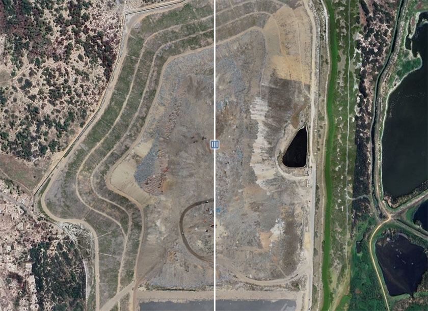
Delta Scan surveys active and closed landfill sites by drone, producing a full coverage surface model of the site at each epoch. Volumes are calculated against the licensed base or design surface for absolute capacity, and against the previous survey for period on period consumption. The result is a measured airspace figure, a quantified fill rate, and a defensible projection of remaining site life. Every deliverable is signed off by a registered professional.
When to use it

Typical engagements.

Each scenario below represents a real-world trigger for this service. If your situation matches one of these, get in touch.

Airspace and capacity reporting

Periodic measurement of consumed and remaining airspace against the licensed void. Waste management licence conditions commonly require capacity reporting, and an estimate is difficult to defend to a regulator or an auditor.

Change analysis between epochs

Surface differencing between successive surveys quantifies exactly how much volume was consumed in the period, where it was placed, and whether the fill sequence is following the approved development plan.

Cell development and closure planning

Design surface comparison for new cell construction, plus capping and rehabilitation volumes for cells approaching closure. Cut and fill quantities are measured rather than estimated from drawings.

Density reconciliation

Surveyed in place volume compared against weighbridge tonnages received over the same period gives an actual compaction density, which is the figure that drives both airspace forecasting and plant performance review.

How it works

Our process.

A repeatable five-stage workflow. The same disciplined sequence runs whether the site is a 500-hectare mining operation or a single 60-metre bridge.

01

Control and baseline

Ground control points are established and surveyed with RTK GNSS, sited off the active face so they survive between visits. Permanent control materially reduces the cost of a recurring monthly or quarterly survey and makes each epoch directly comparable to the last.

02

Flight planning around a live site

Landfills are working sites with plant movement, gas infrastructure, and bird activity. Flight lines, altitude, and timing are planned around the active tipping face and daily operations, so capture proceeds without stopping the site or putting a surveyor on an unstable slope.

03

Capture

Photogrammetric capture produces the surface and a georeferenced orthomosaic. Where intermediate cover, vegetation, or rehabilitated cells obscure ground level, LiDAR is added so the true surface is modelled rather than the canopy above it.

04

Volumetric and change analysis

The processed surface is compared against the licensed base or design surface for total consumed airspace, and against the preceding epoch for period consumption. Outputs include cut and fill mapping, contour plans, cross sections, and slope analysis across the batters.

05

Signed reporting

A signed survey report stating consumed volume, remaining airspace, achieved density against tonnages received where supplied, and projected remaining life at current fill rate. Accuracy is reported from check point analysis. Data and historical epochs are hosted in DeltaCloud so the trend is retained rather than rebuilt each year.

Request a landfill survey quote See GIS and topographic mapping
Equipment

What we use.

Calibrated, sector-matched hardware combined with proprietary software. The capture stack is selected for the asset, not the other way around.

RTK multirotor UAV

Primary capture platform for single site and cell level survey. Direct georeferencing with redundant ground control, flown around live operations without a site shutdown.

Long endurance fixed wing

Large regional sites and multi cell facilities captured in a single mobilisation, where a multirotor would need several flights.

LiDAR payload

Ground return through intermediate cover and vegetation on rehabilitated or dormant cells, where photogrammetry alone would model the canopy instead of the surface.

RTK GNSS ground control

Control and independent check point survey, referenced to Trignet or a local base, giving the accuracy statement that accompanies each report.

Sectors

Where this fits.

The same engineering discipline applies across Municipal landfills, Private waste operators, Mining waste facilities, Industrial and hazardous waste. The detail changes with the asset class and the operational context.

Municipal landfills

Licensed general waste sites, airspace and remaining life reporting to council, cell development and closure planning, illegal dumping and encroachment monitoring

Private waste operators

Commercial landfill airspace as a balance sheet asset, monthly volumetric reconciliation against weighbridge tonnages, compaction and plant performance review

Mining waste facilities

Waste rock dumps, co disposal facilities, and overburden stockpiles surveyed on the same volumetric and change detection basis

Industrial and hazardous waste

Permitted hazardous waste cells, ash disposal facilities, and slag or residue dumps requiring documented capacity and containment geometry

FAQ

Frequent questions.

Direct answers to the questions clients ask most often before engaging.

How often should a landfill be surveyed?

Quarterly suits most municipal sites. High throughput commercial landfills are commonly surveyed monthly, because the airspace figure feeds financial reporting and the fill rate changes fast enough that an annual survey is already out of date when it lands. Annual is the minimum we would recommend for any licensed site.

What accuracy is achievable on a landfill surface?

Volumetric accuracy in the region of 1 to 2 percent against survey grade ground truth is realistic with adequate ground control. Landfill surfaces are rougher and less uniform than stockpiles, so the achieved figure is reported per survey from check point analysis rather than promised in advance.

Can you survey while the site is operating?

Yes. That is the normal case. Capture is planned around the active tipping face and plant movement, and no surveyor has to walk an unstable or freshly placed slope. A site shutdown is not required.

Can you reconcile our surveyed volume against weighbridge tonnages?

Yes, where the tonnage data for the period is supplied. Dividing received tonnage by surveyed in place volume gives achieved compaction density, which is usually more useful to an operator than the volume alone because it points directly at plant and placement performance.

We have older surveys. Can they be used as a baseline?

Usually yes. Previous survey data, design drawings, or a licensed base surface can be brought in as the comparison datum, provided the coordinate reference and datum are known. Where historical data is missing or unreliable, the first survey establishes the baseline and change analysis begins from the second epoch.

Do you cover leachate and gas infrastructure?

Surface infrastructure such as gas wells, leachate manholes, and stormwater controls can be captured and delivered as a positioned GIS layer alongside the volumetric survey, which keeps the site plan current as cells develop.

Related services

If this fits, these often do too.

Engineering programmes rarely run on a single service. These adjacent capabilities most often pair with the work above.

Accuracy & standards

Built to be signed, not just shared.

Pr EngECSA 202001436

Every engineering deliverable is reviewed and signed by Darryl Epstein, a registered Professional Engineer (Pr Eng, ECSA 202001436).

SAGIsurvey

Geospatial deliverables carry registered land-surveyor sign-off where accuracy must be certified.

Classstated

Every deliverable carries a stated survey accuracy class or BIM level of development (LOD), reported per engagement against check-point analysis.

Standardscited

Findings cross-referenced to the applicable codes (SANS, TMH, EN), with accuracy statements on every report.

Start here

Request a landfill survey quote

Send the brief and our engineering team will review your enquiry and reply within one business day. Prefer to talk first? Call or WhatsApp us below.

Response within 1 business day · Pr Eng or SAGI signed

Start a project Call